Matthew to hammer coastal Georgia and South Carolina, after battering Florida
Hurricane Matthew charged up the Florida coast Thursday night and Friday, punishing the coast with wind gusts up to 100 mph and a surge of ocean waters that engulfed normally dry land. But the storm’s center remained far enough offshore to avoid even stronger winds and a worst-case scenario.
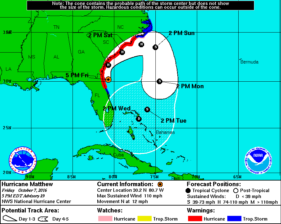
The massive storm will batter coastal Georgia and South Carolina Friday night and Saturday with a dangerous storm surge, damaging winds gusts and flooding rain. If the latest computer model projections are correct, coastal South Carolina could endure a direct hit.
President Obama warned coastal residents not to let their guards down, especially given the storm surge threat. “Remember Sandy,” Obama said, “when people thought it wasn’t as bad as we thought and suddenly we got a massive storm surge.”
Hurricane warnings cover a huge area of the Southeast from Flagler/Volusia county line in northeast Florida to Surf City in North Carolina.
Over a long stretch of coast, a storm surge of about 6 to 9 feet above the ground is possible if its peak coincides with high tide.
Although Matthew had weakened some since Thursday, its maximum sustained winds were still 110 mph Friday afternoon, making it a strong Category 2 hurricane.
As Matthew’s western eyewall grazed Cape Canaveral early Friday, it briefly experienced wind gusts over 100 mph, which ripped off roofs and downed trees
Locations near Daytona Beach experienced several gusts in the range of 70 mph Friday morning as the eyewall drew perilously close. One unofficial observing site gusted to 91 mph between 11 a.m. and noon.
The National Hurricane Center said a private weather station logged an 83 mph gust in New Smyrna Beach Friday morning.
Wind gusts in the Jacksonville area reached 60 to 80 mph.
Over one million Florida homes were reported without power Friday afternoon.
Cities north of Jacksonville, and into Savannah, Ga., are forecast to experience strong winds between Friday afternoon and early Saturday. In South Carolina, the most intense winds are likely early Saturday.
The latest wind speed probabilities from the National Hurricane Center indicate a 60-70 percent chance of coastal South Carolina experiencing hurricane-force winds.
The storm is forecast is continue hugging the coast into Saturday, and it’s not out of the question that the eyewall could drift back onshore over portions of this track.
If Matthew’s eyewall manages to remain offshore the entire time, the cities, affected states and the country will have dodged a disaster by mere miles. That’s not to say that the tropical-storm-force winds, flooding caused by storm surge and rain will not be bad, but the hundreds of miles of destruction brought on by a 120 to 140 mph buzz saw up the coastline would be much, much worse.
“We have been very fortunate that Matthew’s strongest winds have remained a short distance offshore of the Florida Coast thus far, but this should not be a reason to let down our guard,” the National Hurricane Center said Friday evening. “Only a
small deviation to the left of the forecast track could bring these winds onshore.”
On Friday afternoon heavy rains had spread well north of the storm, into Georgia and the Carolinas. Although Matthew is forecast to turn back east over the ocean by the time it reaches North Carolina, an approaching cold front and Matthew’s outer circulation are squeezing moisture out of the atmosphere. Dangerous flooding is expected over the next two days as a result of widespread rainfall totals of 6 to 8 inches, with locally up to a foot or more.
The longer-range track forecast does still include the peculiar loop that started showing up in last Wednesday’s outlooks, but all guidance suggests that the storm will be considerably weaker in five days, and more of nuisance than a threat. The other possibility is that an approaching cold front is deep enough to carry Matthew out to sea for good.
Meanwhile, the story coming out of western Haiti is looking worse and worse. The death tollhas climbed to 842 people, there is fear of a cholera outbreak, and very few structures remain standing on the western Tiburon Peninsula, including in the city of Jeremie.
The eyewall also passed over Nassau and Freeport in the western Bahamas on Thursday, and wreaked havoc there, too.
The monster cyclone has now been a major hurricane for an astounding seven days and counting. But if the eye never crosses the coastline, this record-setting storm will not officially count as a landfall and will not end the U.S.’s record 11-year “drought” with no Category 3 or higher hurricane coming ashore.
Washington Post